The National Feral Pig Action Plan
Western Riverina Pest Project, New South Wales
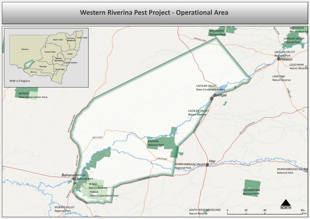
The Western Riverina Pest Project commenced in 2016 and is the largest feral pig control program in Australia, covering 1.4 million hectares.
In 2020, the project expanded to include deer and changed its name from the Western Riverina Pig Project 2016-2019 to the Western Riverina Pest Project and is ongoing.
The project covers an area along the Lachlan River (south of Hillston to the junction with the Murrumbidgee River) and along the Murrumbidgee River west of Hay (Figure 1) and involves 202 holdings (125 landholders). The area covers private land holdings, Yanga National Park, Kalyarr National Park and Lachlan Valley State Conservation Area.
Background of Program
It was initiated in response to NSW Farmers’ members raising concerns about feral pig impacts across the region. This coordinated, strategic, large-scale project is a joint initiative by NSW Riverina, Western and Murray Local Land Services, NSW National Parks and Wildlife Service, NSW Department of Climate Change, Energy, the Environment and Water and NSW Department of Primary Industries and Regional Development. Key stakeholders involved in the project include private landowners, Local Aboriginal Land Councils, and Landcare NSW.
Local impacts caused by feral pigs include:
- Predation of livestock, particularly newborn lambs
- Spreading of disease
- Reduction in crop yields
- Environmental damage to wetlands, the Great Cumbung Swamp, Lowbidgee floodplain
- Water quality
- Threatened species – Plains Wanderer bird (Pedionomus torquatus ), Southern Bell Frog (Litoria raniformsis)
In 2020, the project expanded to include deer and changed its name from the Western Riverina Pig Project 2016-2019 to the Western Riverina Pest Project and is ongoing.
What's been achieved
- Between 2016 and 2024, 62, 191 pigs have been removed from the WRPP area
- Effective collaboration between public and private land managers in feral pig management is being achieved from this project.
| 2016 | 2017 | 2018 | 2019 | 2020 | 2021 | 2022 | 2023 | 2024 |
Population index | 4.32 pigs per km2 | 11.15 pigs per km2 | 2.5 pigs per km2 | 0.75 pigs per km2 | 3.0±1 pigs per km2 | 2.4±0.8 pigs per km2 | No survey | 2.9±1.0 pigs per km2 | No survey |
Reported # pigs removed | 7,764 | 10,730 | 15,174 | 3,271 | 1,520 | 8,608 | 2,367 | 3,716 | 9,041 |
Further details:
- August 2016 – Thermal, forward-facing camera, manual observation, fixed strip estimation method.
- July 2017 – Thermal, forward-facing camera, manual observation, fixed strip estimation method.
- July 2018 – Thermal, perpendicular facing camera, camera upgraded, software image classification, fixed strip estimation method, truncated at 65m from helicopter.
- August 2019 – Thermal, perpendicular facing camera, software image classification, fixed strip estimation method, truncated at 10m from helicopter.
- August 2020 – Thermal, perpendicular facing camera, software image classification, fixed strip estimation method, truncated at 10m from helicopter. Only nine of the 18 survey blocks were sampled. Density was revised in 2021 following the pooling of data.
- August 2021 – Thermal, perpendicular facing camera, manual observation. Nine of the 18 survey blocks were sampled
- August 2023 – Thermal, stratified, data pooled with previous years’ survey data to facilitate analysis using distance sampling. Feral pigs were only detected in the high-quality pig habitat strata
- The reported number of pigs removed is predominantly attributed to LLS funded programs particularly from 2020 onwards. From 2016 to 2019 the figures include some privately funded control strategies. Given there is limited data on individual and privately run control activities, it is assumed that the true figure would be significantly higher than what has been reported.
Who's involved?
Governance
The project is overseen by the WRPP Executive Committee. The committee’s membership is comprised of senior executives from:
- NSW Department of Primary Industries and Regional Development – Invasive species team (Chair)
- NSW Riverina Local Land Services
- NSW Western Local Land Services
- NSW Murray Local Land Services
- NSW National Parks and Wildlife Service
- NSW Department of Climate Change, Energy, the Environment and Water – Environmental watering division
The executive committee meets at least 3 times per year and is focused on securing on-going funding for project activities and planning strategic and integrated control strategies.
The project is delivered with support from an operational committee. Operational committee member are representatives from the same organisations as the executive committee with an additional three landholder representatives and a standing invitation to local aboriginal land councils within the project area.
Stakeholder Consultation
Local Land Services biosecurity staff from the three regions engage with landholders and stakeholders through pest related capacity building events, joining local agricultural related events, and through targeted communications such as mailouts, newsletters, email updates etc.
Activities being conducted
The project area includes extensive flood plains that are frequently inundated and largely inaccessible on ground. These areas rely on aerial shooting with opportunistic ground control when conditions allow.
For the remaining project area, 1080 poison baiting is promoted as the preferred control technique. On properties that do not want to use 1080 poison, Local Land Services supports trapping through the provision of traps.
Although not encouraged by the project, numerous properties in the project area allow recreational hunting with some turning an income through charging for accommodation and property access. The project understands that this control method will remain and so is focussed on educating the community about integrated pest management and timing of operations so as not to impede the success of a control method.
On the National Parks and Wildlife Service managed land, a combination of primary and supplementary control techniques are adopted and dependent on public access requirements at the time
The aim of survey and monitoring has been to evaluate the costs and effectiveness of feral pig control operations and to identity geographical hotspots for targeted control activities.
Survey methods used in the WRPP have evolved since 2016 and the methods used to analyse the data have varied from year to year and between different analysts. This is important to note when comparing the density index from year to year (refer to the notes under the table in the ‘Outcomes to date’ section.
The latest survey design is stratified into high, medium and low-quality feral pig habitats as shown in the figure below.
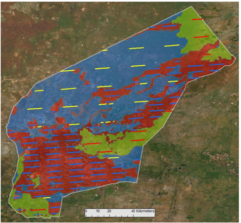
Figure 2: Stratified, segmented grid design flown during the thermal surveys over the Western Riverina Pest Program since August 2023. Red, green, and blue shading relate to high, medium, and low-quality feral pig habitats respectively. Blue, red, and yellow lines show the high, medium and low stratum transect lines respectively.
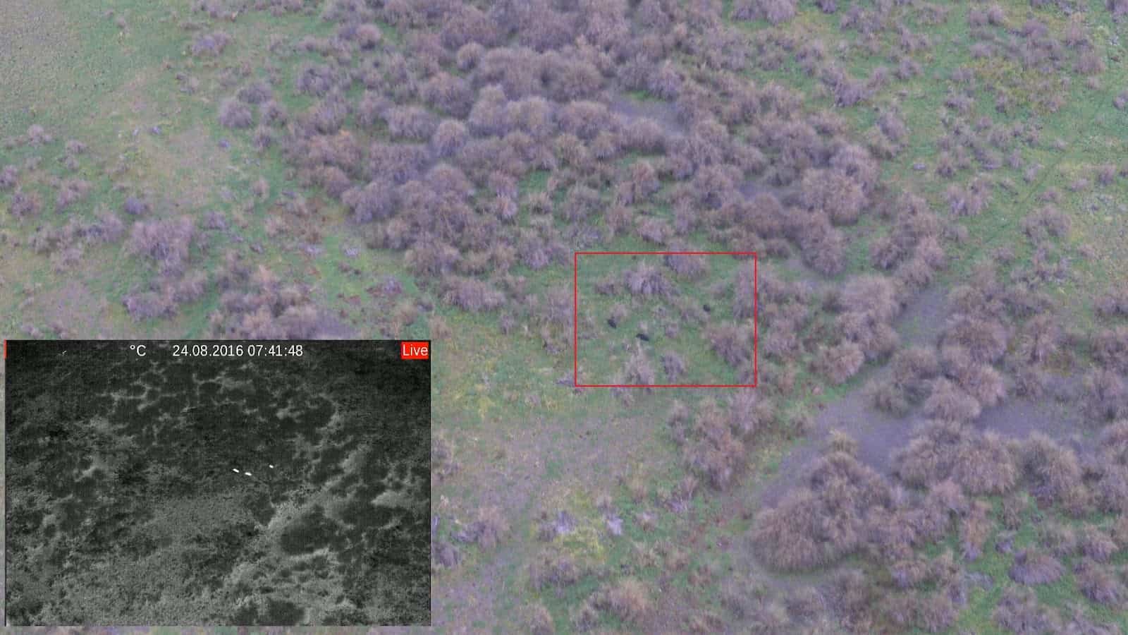
Figure 3: Feral pigs being picked up by the thermal camera survey
In 2019 the project trialled thermal drone surveying to evaluate its effectiveness compared to the existing helicopter survey method.
At the time the limitations of the drone prevented it from being a viable alternative to the helicopter survey.
The use of a thermal camera to aid in aerial shooting was trialled within the project area in 2021 and then again on three occasions in 2024. This research was led by Dr Tarnya Cox from the NSW Department of Primary Industries and Regional Development – Vertebrate Pest Research Unit.
The project is planning to host further research trials related to TAAC in the future.
From time-to-time LLS has supported research requiring biological sampling of feral pigs.
- 2020 – DNA testing for genetic relatedness between populations. Results suggested feral pigs were not closely related between different locations within the program area.
- May 2024 – Disease monitoring. Testing included Japanese encephalitis virus, Flaviviruses, Brucella suis and Leptospira spp. 28 out of 40 had been infected with Leptospirosis.
- March 2025 – Disease monitoring. Results pending.
Local Land Services values capacity building of land managers to implement effective control strategies. Capacity building for WRPP landholders occurs through:
- workshops with practical demonstration and guest presenters.
- on-site one-on-one engagement between LLS Biosecurity staff and landholders.
- Provision of printed resources and learning material
- Support from experienced pest control contractors when funding permits.
In March 2021, 20 feral pigs were collared in the lowbidgee floodplain. In October 2021, 13 pigs were collared near Booligal. The collars were fitted as part of a research study into the effects of aerial shooting on feral pig movements. The project also created an engagement opportunity with landholders and gave rise to discussion related to how far feral pigs are moving in the landscape.
The collared pigs have now been dispatched. The results of the study have been submitted for publishing by lead researcher Dr Andrew Bengsen from NSW Department of Primary Industries and Regional Development – Vertebrate Pest Research Unit.
An outdoor trail camera was installed in the program’s early years. Unfortunately, vandalism and access limitations throughout the seasons resulted in an incomplete dataset for effective population monitoring by this method.
Cameras are routinely utilised to monitor control sites during free feeding for non-target species and risks.
Funding
The WRPP has been funded from commonwealth and state government initiatives including:
- Commonwealth Pest and Weed Drought Funding 2016 – 2019
- National Landcare Program 4
- NSW Foot and Mouth disease prevention and preparedness program
- NSW Feral Pig Program
- NSW Feral Pig and Pest Program
- NSW Local Land Services – Special Purpose Pest Management rate
In the media
In recognition of the significant achievements being delivered by the Western Riverina Pest Program, the Program was awarded the 2021 Froggatt Award by the Invasive Species Council in March 2022.
- National award for Western Riverina feral pig eradication program | About Regional
- Riverina pest program snatches award for removal of 40,000 feral pigs
- Thousands of feral pigs shot during aerial cull across 750,000 hectares of the NSW Riverina – ABC News
- Western Riverina Pest Project removes 40,000 feral pigs and wins national award | Mirage News
- Feral pig control program recognised
- Australasian Vertebrate Pest Conference 2017
- National Feral Pig Conference 2023 – ‘Evaluating the Western Riverina Pest Program from 2016 to 2022
- National Feral Pig Conference 2023 – ‘Thermal Aerial Surveillance Considerations for feral pig monitoring in Western Riverina NSW’
- Andrew J Bengsen et al (in review) Aerial shooting does not cause consistent changes in feral pig (Sus scrofa) movements.
Further Information
NFPAP feature articles
Aerial autumn pest offensive- Western Riverina Pest Project, May 2022
Official pages and links
Western Riverina Pig Project – YouTube
Contact
Suzie Holbery, Regional Pest Animal Coordinator, Riverina Local Land Services – suzie.holbery@lls.nsw.go.au
Michael Leane, Manager Biosecurity and Emergency Services, Riverina Local Land Services – Michael.leane@lls.nsw.gov.au
Figures have been supplied by Western Riverina Pest Program and NSW Government Local Land Services.